Kentucky tornado records · 2025 research
One Kentucky tornado became three records in the weather archive
A homeowner looking up a county's tornado history needs to know what the database is counting. The tornado that crossed Russell, Pulaski and Laurel counties on May 16, 2025 appears in NOAA's Storm Events archive as three event records belonging to two episodes. The National Weather Service's account describes one tornado.
That is not a contradiction. It is a consequence of documenting a moving hazard across administrative boundaries. But it matters when a list of historical records becomes a headline about how many tornadoes occurred near someone's home.
HomeRiskIQ traced the three records in the complete 2025 archive downloaded from NOAA on October 31, 2026. The useful finding is not another tornado ranking. It is a concrete example of why a count of database rows cannot automatically answer a question about separate tornadoes. NOAA source archive
Following the county boundary
The Russell County record points to Pulaski County in its continuation fields. The Pulaski record then points to Laurel County. Those fields are not incidental: NOAA's schema specifically uses them to identify the county and forecast office entered by a continuing tornado segment. The record identifiers are 1263465, 1292921 and 1292941. NOAA bulk data documentation
The episode identifiers do not solve the counting problem on their own. Russell's segment belongs to episode 202784; Pulaski and Laurel belong to episode 207048. The records also span the Louisville and Jackson forecast offices. Grouping only by episode would leave two groups for the same tornado, while counting each event identifier would produce three.
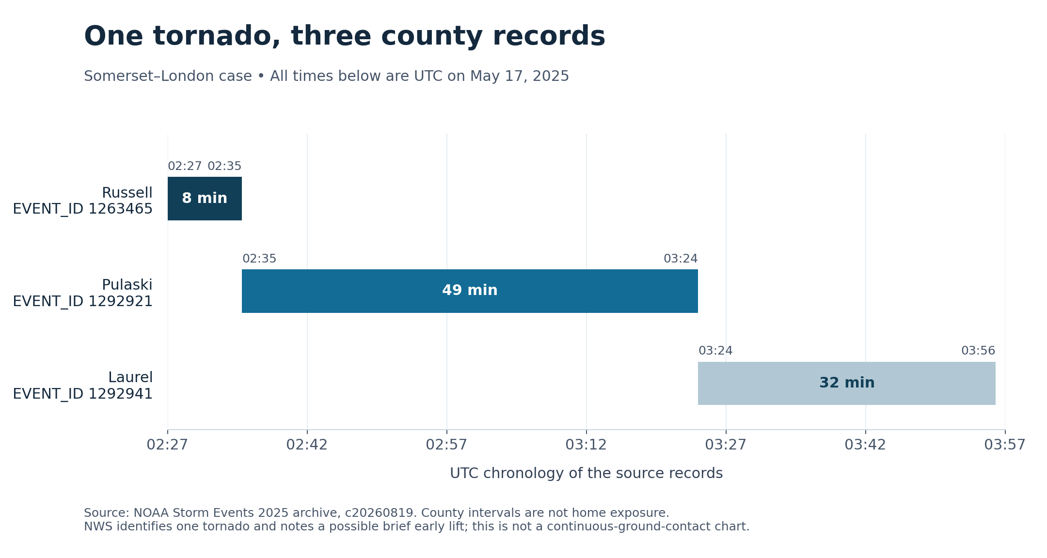
The clock requires another check. Russell's stored times use Central Standard Time, while the next two records use Eastern Standard Time. Read without those offsets, Russell's ending time of 20:35 and Pulaski's starting time of 21:35 appear an hour apart. Converted to UTC, both are 02:35 on May 17. Pulaski's ending time and Laurel's beginning time also match, at 03:24 UTC.
| County / event ID | Begin UTC (May 17, 2025) | End UTC | Record interval (minutes) | Segment length (miles) |
|---|---|---|---|---|
| Russell / 1263465 | 02:27 | 02:35 | 8 | 7.78 |
| Pulaski / 1292921 | 02:35 | 03:24 | 49 | 32.3 |
| Laurel / 1292941 | 03:24 | 03:56 | 32 | 20 |
Scroll the table horizontally on smaller screens. Full-precision values and definitions are in the chart-data CSV and evidence ZIP.
A survey supplies the physical meaning
The independent basis for calling this one tornado is the Weather Service's account, not an algorithm that happens to link three rows. The official Jackson event page describes the tornado crossing all three counties and links to a survey update issued May 22, 2025. That update also notes evidence that the tornado may briefly have lifted near its beginning. NWS event account, NWS survey text preserved by Iowa Environmental Mesonet
The products do not agree exactly on length. The earlier survey reports 59.92 miles. Adding the three segment-length fields in the frozen archive gives 60.08 miles. This analysis does not resolve that 0.16-mile difference or assume its cause. The segment sum should not be relabeled as the survey's total, and the earlier survey should not silently overwrite the later archive.
The records also carry different segment ratings: EF3 in Russell and EF4 in Pulaski and Laurel. A segment rating describes the recorded damage classification for that segment; it does not mean every home across that county experienced those conditions. Nor can a county-wide record identify which properties lay in the surveyed damage path.
Reading a history before applying it to a home
For a reader checking a neighborhood's history, the first question is what a displayed number represents: county segments, episode identifiers or individually reconciled tornadoes. The next is whether a mapped line is an actual surveyed path or a simplified connection between record endpoints. Those are different levels of geographic evidence.
This case is deliberately limited to one documented tornado. It does not recalculate Kentucky's annual tornado total, and it does not establish that all continuation links elsewhere are complete. Other tracks would need their own checks, including official surveys where available.
Historical records can help identify the events worth examining more closely. They cannot replace current warnings or turn a county total into a property-specific forecast. In this example, keeping the record identifiers, continuation fields and time zones visible preserves the history without multiplying one tornado into three.
Methods and interpretation limits
The frozen NOAA 2025 details archive was retrieved October 31, 2026; its creation date is August 19, 2026. Records and episode identifiers do not automatically count independent physical storms. Administrative reporting, category selection, missing context and source revisions limit interpretation.
These purposively selected cases explain database identity, timestamps and geography. They do not estimate home exposure, future loss, climate trends or property-level risk, and do not alter the site’s scoring model.
The county-record lengths sum to 60.08 miles, while the earlier agency survey reports 59.92 miles. The 0.16-mile difference remains unreconciled; neither value replaces the other. UTC-adjacent record intervals do not establish uninterrupted ground contact or a home’s exposure.
Read the full archived methodology. The evidence ZIP preserves frozen source files, source provenance and reproduction scripts.
Sources and context
Data and chart downloads
The evidence download is shared with the related studies that use the same source files. Keep the original folder layout when extracting it. Source and sensitivity records retained for reproducibility do not constitute additional published stories.