Kansas wind and hail · 2025 research
What a Kansas weather count hides about wind and hail
HomeRiskIQ analysis of 2025 NOAA records for Sherman and Sedgwick counties
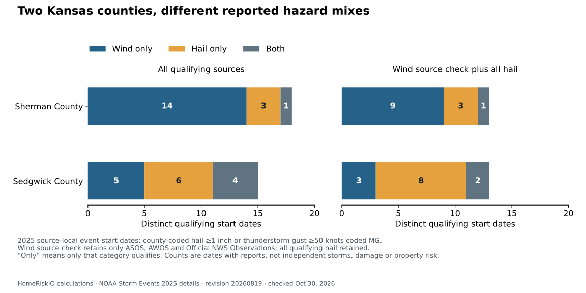
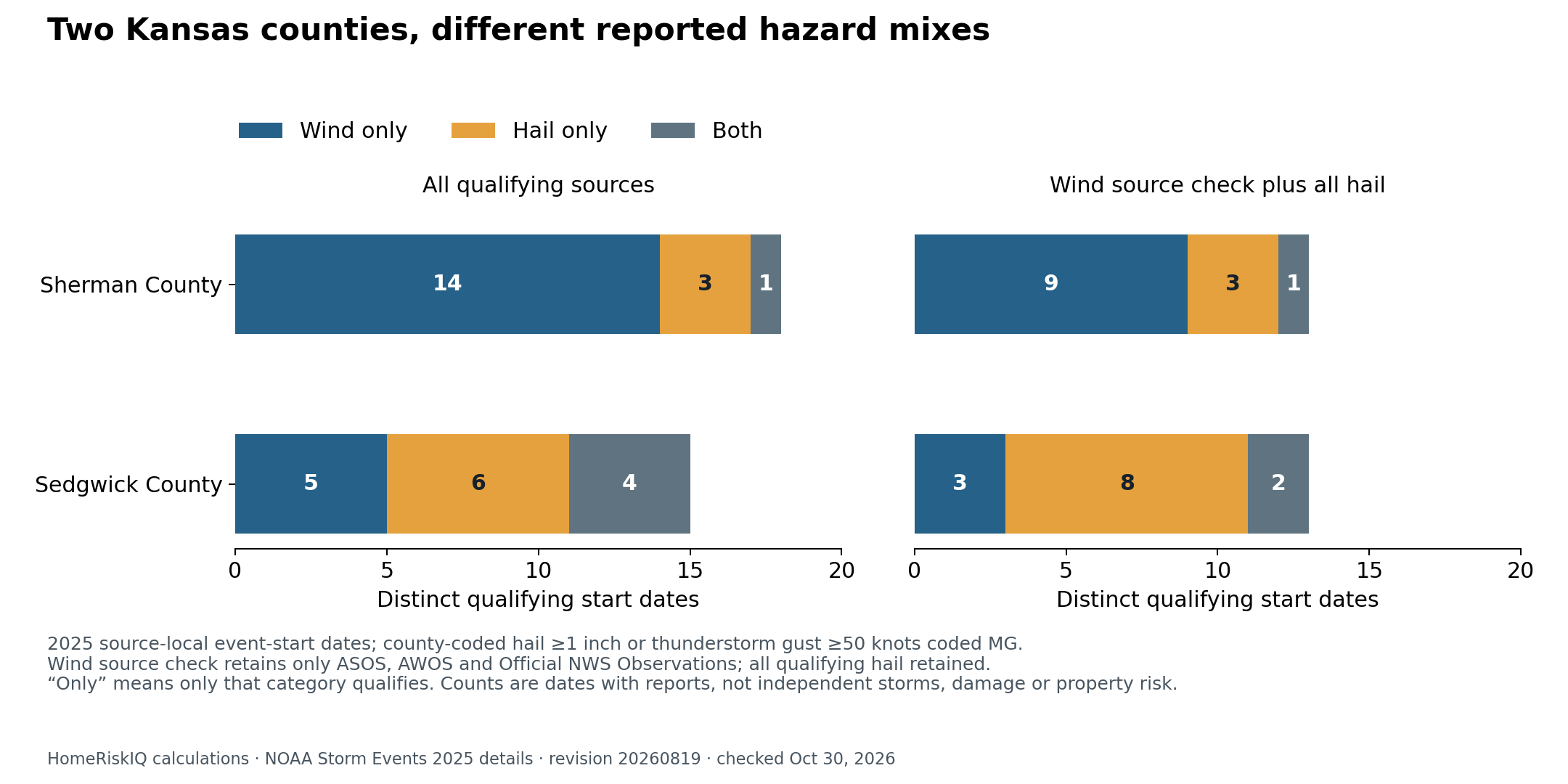
Sherman County and Sedgwick County produced different wind-and-hail profiles in a HomeRiskIQ analysis of NOAA's 2025 Storm Events archive. Sherman had 14 qualifying dates with wind reports but no qualifying hail report. Sedgwick had five. Hail without qualifying wind appeared on three dates in Sherman and six in Sedgwick; both categories appeared on one date and four dates, respectively.
That distinction is more useful than declaring a winner from the annual totals of 18 dates in Sherman and 15 in Sedgwick. Those totals depend on which reporting sources are included. In a narrower source check, both counties finish with 13 qualifying dates. The comparison illustrates how much information a single county weather count can leave out. NOAA 2025 source file
The analysis counts county-coded hail reports of at least one inch, or Thunderstorm Wind reports of at least 50 knots that NOAA codes as measured gusts, identified by “MG.” Multiple qualifying reports in the same county on the same recorded event-start date count once. Hail sizes can be estimated or measured. Neither a report nor a counted date establishes that an entire county, neighborhood or home experienced that weather. NOAA field definitions
Two different mixes
| Qualifying event start dates in 2025 | Sherman County | Sedgwick County |
|---|---|---|
| Wind only | 14 | 5 |
| Hail only | 3 | 6 |
| Both wind and hail | 1 | 4 |
| Total distinct dates | 18 | 15 |
“Only” means only one category meets this analysis's reporting and magnitude filters, not that the other hazard was absent.
Sherman's one date with both categories was May 18. Its records include hail reports referenced to Ruleton and Caruso, alongside a measured gust at Goodland Airport. NOAA's airport entry records 52 knots. Together they qualify as one county date, not three separate storms. NOAA May 18 event record
The measured-wind label also covers more varied circumstances than a reader might picture from “thunderstorm season.” Sherman's archive narratives describe gusts associated with decaying showers, convection and blowing dust. The analysis retains NOAA's event classifications; it does not recategorize every entry as a classic thunderstorm or treat it as evidence of damage.
The reporting network changes the comparison
For the source check, HomeRiskIQ retained all qualifying hail reports but limited wind reports to the source categories ASOS, AWOS and Official NWS Observations. Sherman's mix then becomes nine wind-only dates, three hail-only dates and one with both. Sedgwick's becomes three wind-only, eight hail-only and two with both. The contrast in composition remains, while the apparent difference in annual totals disappears.
That check is not a complete or equally dense observing network. Excluded measured-gust records can come from mesonets, trained spotters and other observers; the remaining stations also differ in location and coverage. Raising the thresholds to 1.5-inch hail or 60-knot measured gusts reduces the county totals to seven and six. Neither test produces a ranking of which county is safer.
For homeowners reading a storm-history summary, the useful questions are what was reported, where, and under which definition. These county records do not measure roof damage, insurance losses or the chance of a future claim. They also do not establish a climate trend: this is one calendar year, with no comparable historical baseline. Splitting the count into wind, hail and overlapping dates makes the limitations visible instead of hiding them inside one number.
Data note: The 2025 file was freshly downloaded October 30, 2026, and matches NOAA's currently listed August 19, 2026 revision. Dates are the source-local event-start dates, not independent storms or every date an event touched. The accompanying chart and reproducible data apply the same definition throughout.
Methods and interpretation limits
Count distinct recorded local event-start dates within the exact county: county-coded hail at least 1 inch, or Thunderstorm Wind at least 50 knots coded MG. Hail may be estimated or measured; MG is NOAA’s coding, not independent instrument verification. These are dates with reports, not independent storms or loss probabilities.
Sensitivity checks raise the thresholds to 1.5-inch hail or 60-knot MG wind, and separately restrict wind sources to ASOS, AWOS and Official NWS Observations while retaining all qualifying hail. No check guarantees equal reporting coverage. Narrative/coding conflicts and their unchanged-date sensitivity are retained in the methods.
The frozen NOAA 2025 details file is revision 20260819, retrieved and checked October 30, 2026. No selected record crosses midnight; date-component and one-hour-shift checks preserve the date sets. One year of reports supplies no climate-trend baseline.
Read the full archived methodology. The evidence ZIP preserves frozen source files, source provenance and reproduction scripts.
Sources and context
Data and chart downloads
The evidence download is shared with the related studies that use the same source files. Keep the original folder layout when extracting it. Source and sensitivity records retained for reproducibility do not constitute additional published stories.