Black Hills calendars · 2025 research
Equal weather totals hide different calendars in two Black Hills counties
HomeRiskIQ analysis of 2025 NOAA records for Pennington and Meade counties
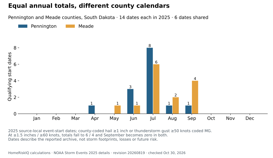
Pennington and Meade counties each had 14 qualifying wind-or-hail dates in a HomeRiskIQ analysis of NOAA's 2025 Storm Events archive. Only six dates appeared in both counties. The other eight in each county fell on different dates, leaving 22 distinct dates across the pair.
An annual total alone would miss that difference. July accounted for eight of Pennington's dates and six of Meade's. September contributed one in Pennington and four in Meade. This describes a filtered reporting calendar, not greater danger or a shift toward later storms. NOAA 2025 source file
The rule includes county-coded hail reports of at least one inch and Thunderstorm Wind reports of at least 50 knots coded by NOAA as measured gusts, or “MG.” Reports are grouped by each event's recorded local start date, with each county counted once per date. A storm can generate several reports, affect both counties or last across dates; these totals do not count independent storms. Hail size reports are not necessarily instrument measurements. NOAA field definitions
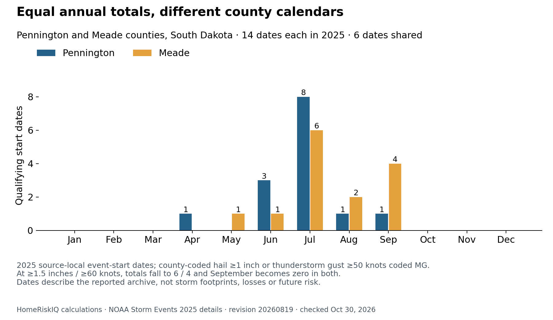
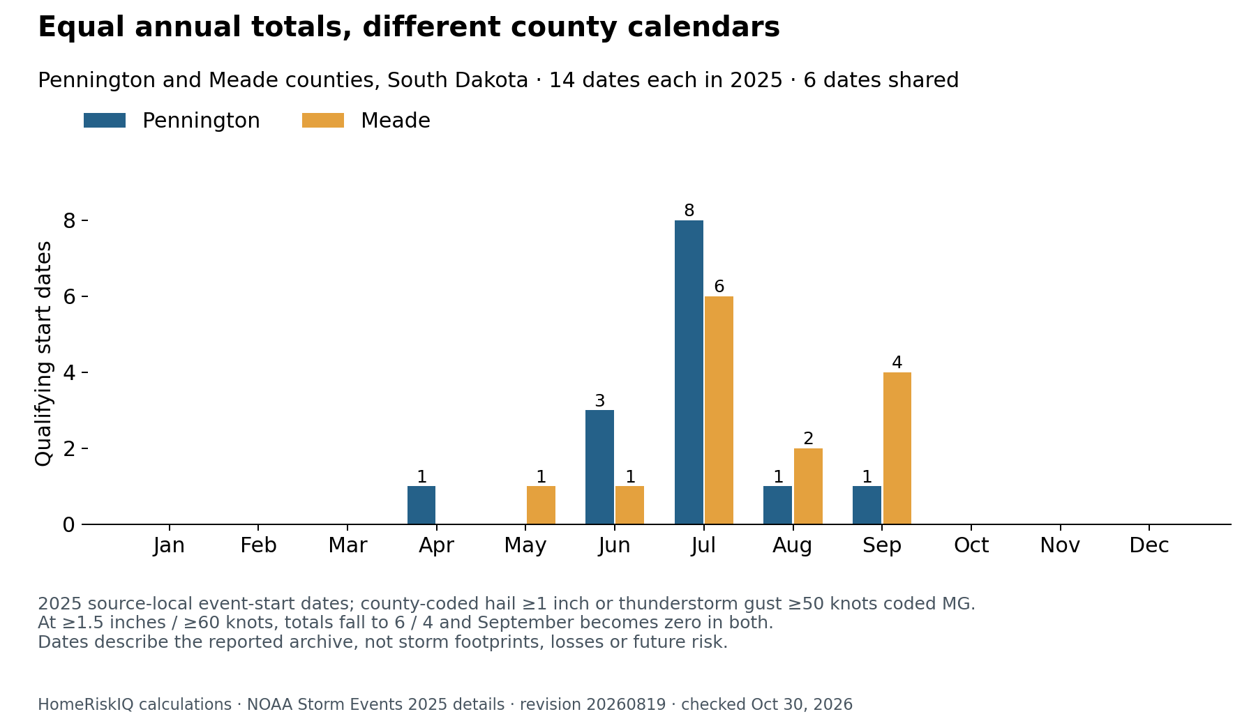
The calendar behind the tie
| Month with qualifying reports | Pennington County | Meade County |
|---|---|---|
| April | 1 | 0 |
| May | 0 | 1 |
| June | 3 | 1 |
| July | 8 | 6 |
| August | 1 | 2 |
| September | 1 | 4 |
| Full year | 14 | 14 |
January through March and October through December had no qualifying start dates in this filtered archive. That does not establish an absence of hazardous weather.
The six shared dates were June 28, July 5, July 10, July 19, August 13 and September 10. A shared date means qualifying records exist in both counties, not identical storm footprints or intensity. Likewise, a date found in only one county does not prove the neighboring county escaped the weather.
The September entries make the distinction concrete. Both counties had qualifying wind records on September 10. Meade also had a hail report on September 11 and qualifying wind records on September 13 and 15. Those observations describe particular reported locations, not all of Sturgis, Rapid City or the surrounding countryside. The analysis uses NOAA's county assignments rather than relabeling county-wide records as city weather.
A threshold check limits the September story
The late-season contrast disappears when the analysis raises its thresholds to 1.5-inch hail or 60-knot measured gusts. At those cutoffs, the full-year totals become six dates in Pennington and four in Meade, with no September dates in either county. The original September result therefore concerns the lower-threshold reports; it cannot support a claim about unusually intense or persistent late-season storms.
Reporting sources matter too. Keeping all qualifying hail but restricting wind to ASOS, AWOS and Official NWS Observations reduces both county totals to nine. That is a sensitivity test, not a correction or a guarantee of equally complete coverage. The broader archive includes mesonet and other measured-gust reports. Removing several records whose short narratives conflict with their coded classification leaves the primary date totals unchanged.
For readers comparing local weather histories, the finding is a reason to inspect the calendar and source definitions before comparing annual totals. This analysis does not estimate damage, repair demand, insured losses or property-level exposure. It excludes other weather categories, including High Wind, and supplies no historical baseline for a trend. The defensible conclusion is narrower: two equal counts in the 2025 archive describe different sets of recorded dates.
Data note: NOAA's currently listed August 19, 2026 revision was freshly downloaded and checked October 30, 2026. Neither county's qualifying records crosses midnight; adding one hour to their recorded starts does not change the date sets. The accompanying chart includes all 12 months.
Methods and interpretation limits
Count distinct recorded local event-start dates within the exact county: county-coded hail at least 1 inch, or Thunderstorm Wind at least 50 knots coded MG. Hail may be estimated or measured; MG is NOAA’s coding, not independent instrument verification. These are dates with reports, not independent storms or loss probabilities.
Sensitivity checks raise the thresholds to 1.5-inch hail or 60-knot MG wind, and separately restrict wind sources to ASOS, AWOS and Official NWS Observations while retaining all qualifying hail. No check guarantees equal reporting coverage. Narrative/coding conflicts and their unchanged-date sensitivity are retained in the methods.
The frozen NOAA 2025 details file is revision 20260819, retrieved and checked October 30, 2026. No selected record crosses midnight; date-component and one-hour-shift checks preserve the date sets. One year of reports supplies no climate-trend baseline.
Read the full archived methodology. The evidence ZIP preserves frozen source files, source provenance and reproduction scripts.
Sources and context
Data and chart downloads
The evidence download is shared with the related studies that use the same source files. Keep the original folder layout when extracting it. Source and sensitivity records retained for reproducibility do not constitute additional published stories.